Antarctic Circle Map | Facts, Location & Scientific Importance
The Antarctic Circle is a dynamic boundary. Our guide explains its shifting latitude, extreme climate, and unique geography. Learn the science behind this frigid zone.
Author:Michael RachalReviewer:Finn WildeSep 08, 20251.6K Shares200.7K Views
The Antarctic Circle is one of the world's most significant yet misunderstood geographical lines. It's not a static mark on a paper map but a dynamic astronomical boundary that defines the southern polar region.
Understanding the Antarctic Circle mapmeans grasping the fundamental forces that shape our planet's most extreme environment. It's a demarcation that has guided explorers, defined climate zones, and served as a crucial reference point for scientists.
For those who have studied polar geography, the Antarctic Circle represents a doorway to a world of extremes: a realm of 24-hour daylight in summer and unending darkness in winter.
This article will not only provide a detailed look at the Antarctic Circle but will also synthesize the geological, climatic, and biological truths that make it a place of such immense scientific importance.
Quick Facts About The Antarctic Circle Map
| Latitude | 66°33′50.6″ south of the Equator (shifts slightly each year). |
| Reason for Location | Determined by Earth’s 23.5° axial tilt. |
| Area Covered | About 20 million km² (7.7 million sq mi), roughly 4% of Earth’s surface. |
| Circumference | Around 16,000 km (9,900 mi). |
| Dynamic Nature | The Antarctic Circle is not a fixed line. Its position shifts south by about 14.5 meters (48 ft) per year due to the Earth's changing axial tilt. |
| Capital City | None |
| Official Language | None |
| Official Currency | None |
The Antarctic Circle Defined & Explained
Location And Meaning
The Antarctic Circle is a parallel of latitude located at approximately 66°33′50.6″ south of the Equator. This is one of the five major circles of latitude, separating the Southern Temperate Zone to its north from the South Frigid Zone to its south. Its location is directly tied to the Earth's axial tilt of 23.5 degrees.
The Circle marks the northernmost point where the sun can remain continuously above the horizon for 24 hours at least once a year (the midnight sun). Conversely, it's also the northernmost point where the sun remains below the horizon for a full 24 hours at least once a year (the polar night).
The duration of these phenomena increases as one travels further south, culminating in six months of continuous day and six months of continuous night at the South Pole.
The Shifting Boundary: Why The Latitude Isn't Fixed
A common but incorrect assumption is that the Antarctic Circle's position is static. Its exact latitude is in constant, albeit minute, flux. This subtle movement is a direct result of the Earth’s axial wobble, or nutation, which fluctuates within a margin of more than 2° over a 41,000-year period. This long-term cycle is due to tidal forces exerted by the Moon's orbit.
Consequently, the Antarctic Circle is currently drifting southwards at a speed of about 14–15 meters (48 ft) per year. This means that any static map of the Antarctic Circle is a snapshot in time.
For a truly unique visual, atmospheric refraction and mirages can make the sun visible up to 90 km north of the circle's exact latitude, further blurring the line in a real-world context.
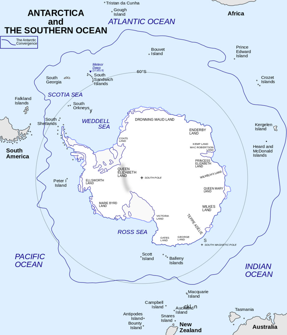
Area And Geography
The area south of the Antarctic Circle covers roughly 20 million km² (7.7 million sq mi), which is about 4% of Earth’s surface. Its total circumference is approximately 16,000 km (9,900 mi).
The circle crosses only ocean and ice, highlighting the extreme isolation of this region. Unlike its Northern Hemisphere counterpart, the Arctic Circle, which passes through eight countries, the Antarctic Circle passes through a vast ocean and the continent of Antarctica, which is governed by an international treaty.
Antarctica Vs. The Antarctic Circle: A Crucial Distinction
It's a common mistake to think that Antarctica and the Antarctic Circle are the same. They are not.
- The Antarctic Circle is an imaginary line of latitude. It is a boundary, not a place itself.
- Antarctica is a massive continent of ice and rock. It is a place.
Almost all of the continent of Antarctica lies withinthe Antarctic Circle. The most famous parts of Antarctica, including the South Pole, are deep inside this boundary.
Mapping The Circle's Ecosystem: Features On The Antarctic Circle Map
While it looks like a vast, empty wilderness from above, detailed maps of the Antarctic Circle reveal an intricate patchwork of important features.
Ice Shelves And Glaciers
The most prominent mapped features are Antarctica’s enormous ice shelves, which act as crucial barriers that slow the flow of glaciers behind them. When these shelves collapse, glaciers accelerate, contributing to global sea-level rise.
- Ross Ice Shelf:Roughly the size of France, this is the largest ice shelf on the continent.
- Ronne-Filchner Ice Shelf:The second-largest, it borders the Weddell Sea.
- Larsen Ice Shelf:Famous for its dramatic collapses, such as the Larsen C calving event in 2017.
Research Stations
Unlike the Arctic, which has permanent settlements, Antarctica hosts seasonal and year-round research stations that serve as crucial waypoints for science and logistics.
- McMurdo Station (USA):The largest station, supporting thousands of people in summer.
- Amundsen–Scott South Pole Station (USA):Located directly at the geographic South Pole.
- Vostok Station (Russia):A key hub for climate studies, built over subglacial Lake Vostok.
- Concordia Station (France/Italy):A hub for astronomy and climate research.
The Continent Within The Circle: Key Facts
The landmass inside the Antarctic Circle is a place of extremes. It's the coldest, driest, and windiest continent on Earth.
Climate And Environment
Antarctica is technically a desert, receiving only about 166 millimeters of precipitation each year. The lowest air temperature ever recorded was -89.2°C (-129.3°F) at Vostok Station, with more recent satellite measurements detecting temperatures as low as -98°C (-144°F). Powerful katabatic winds flow from the continent's interior, sometimes reaching hurricane-force velocities.
Geography And Geology
The continent’s highest point is Vinson Massif (4,897 m), and its lowest is the Bentley Subglacial Trench(-2,555 m). The massive ice sheets average 1.6 km in thickness and depress the bedrock, creating unique subglacial features like Lake Vostok.
This weight has shaped the landscape, which is the focus of ongoing scientific projects documented in resources like the 2024 Antarctic Digital Database.
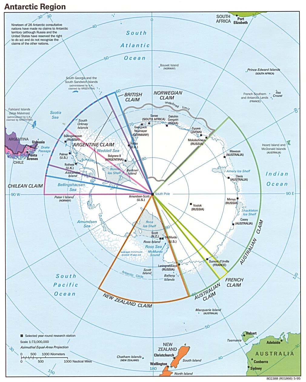
Claims And Governance
While several nations have made territorial claims on parts of Antarctica, the continent is governed by the Antarctic Treaty System. This treaty places all claims on hold and reserves the land for peaceful, scientific research. The seven countries with claims are Argentina, Australia, Chile, France, New Zealand, Norway, and the United Kingdom.
Human Presence And Life
There is no official permanent population in Antarctica. Its only human inhabitants are scientists and support staff who live in research stations. However, the region has become a popular tourist destination, with over 100,000 visitorsduring a recent season. The harsh climate supports only a few species of hardy plants, such as lichens and mosses.
The Antarctic Circle Vs. Other Circles Of Latitude
Understanding the Antarctic Circle is easier when it's compared to its siblings.
Arctic Circle
Located at approximately 66°33′ north, the Arctic Circle crosses through eight nations, including Norway, Sweden, Finland, Russia, the USA (Alaska), Canada, Greenland (Denmark), and Iceland. Unlike Antarctica, it is home to indigenous peoples, cities, and industries.
Tropic Of Cancer & Tropic Of Capricorn
These lines define the northernmost and southernmost points where the sun can be directly overhead. Located at approximately 23°26′ north and south, they mark solar zeniths rather than the polar extremes of continuous light and darkness.
Equator
Located at 0°, the Equator divides Earth into the Northern and Southern hemispheres. Unlike the Antarctic Circle, it is warm, wet, and densely populated. The Antarctic Circle is unique in its emptiness: no cities, no borders in practice, and no permanent human habitation.
Countries And Territorial Claims In Antarctica
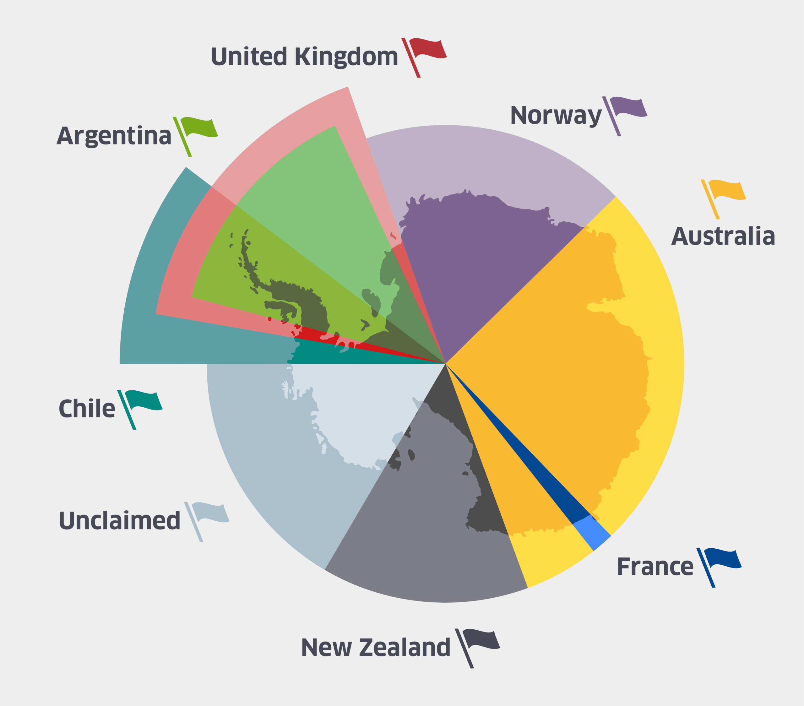
While no countries are located withinthe Antarctic Circle, seven nations have laid territorial claims on portions of Antarctica, which extends beyond the circle. These claims, and the continent itself, are governed by the Antarctic Treaty System, established in 1959, which ensures the land is used for peaceful purposes and scientific research.
- Argentina:Claims Argentine Antarctica, which overlaps with both Chileand the UK.
- Australia:Holds the largest claim, the Australian Antarctic Territory, covering about 42% of the continent.
- Chile:Claims the Chilean Antarctic Territory, which overlaps with Argentina and the UK.
- France:Administers Adélie Land, a narrow slice of East Antarctica.
- New Zealand:Claims the Ross Dependency, which includes the Ross Ice Shelf.
- Norway:Claims Queen Maud Land, a vast section of East Antarctica.
- United Kingdom:Claims the British Antarctic Territory, which overlaps with Chile and Argentina.
It is important to note that many of these claims are not recognized internationally and remain in a disputed status, all of which is placed on hold under the terms of the Antarctic Treaty.
Why The Antarctic Circle Matters
Maps of the Antarctic Circle are not just academic exercises. They help us understand global climate, science, and geopolitics.
Climate Research
Antarctica plays a key role in global climate regulation. Its massive ice sheets reflect sunlight, cooling the planet, and the melting of ice directly impacts global sea-level rise. Ice cores extracted here reveal up to 800,000 years of climate history, and mapping glacial retreat within the Circle provides visual proof of climate change.
Navigation & Exploration
In earlier centuries, navigators risked their lives to chart the icy seas around the Circle. Today, mapping tools guide research expeditions, icebreaker routes, and even cruise ships offering “bucket list” journeys across 66°33′ S.
Governance & Cooperation
Because of the Antarctic Treaty, maps showing territorial claims reinforce one of Earth’s rarest international agreements: a continent reserved for science, not war or exploitation.
Common Misconceptions About The Antarctic Circle
- It’s a fixed line- In reality, it shifts annually due to axial tilt.
- It marks the edge of Antarctica- Not true. The continent extends beyond the Circle in some places (e.g., Antarctic Peninsula).
- It’s lifeless- While harsh, it supports penguins, seals, whales, and microbial life adapted to the cold.
- Only scientists care- The Antarctic Circle’s climate impact affects everyone, from coastal dwellers to global agriculture.
FAQs About The Antarctic Circle Answered
What Latitude Is The Antarctic Circle?
The Antarctic Circle lies at 66°33′50.6″ south latitude, though it shifts slightly each year.
How Big Is The Antarctic Circle?
Its circumference is about 16,000 km, enclosing roughly 20 million km²- nearly the size of all South America and Europe combined.
How Is The Antarctic Circle Shown On Maps?
On world maps, it’s usually a dashed parallelnear the bottom. On polar projection maps, it appears as a circular boundary surrounding Antarctica.
Can You Go To The Antarctic Circle?
Yes, it's possible to visit the Antarctic Circle. Many expedition cruises sail to the Antarctic Peninsula and cross the circle, especially during the austral summer.
What Countries Are In The Antarctic Circle?
No countries are located within the Antarctic Circle. While seven nations have made territorial claims on parts of Antarctica, the continent is governed by the Antarctic Treaty System.
Are There Any Cities On An Antarctic Circle Map?
No, there are no cities or permanent settlements within the Antarctic Circle. The only human inhabitants are scientists and support staff who live in research stations.
Why Is 66.5 Degrees So Important?
The significance of 66.5 degrees is that it is the approximate latitude for both the Arctic and Antarctic Circles. This number is directly related to the Earth's axial tilt of about 23.5 degrees.
Final Words
The Antarctic Circle may look like just another latitude line, but it’s one of Earth’s most symbolic and scientifically important boundaries. It marks the transition to a realm of endless day and night, encircles a continent that governs global climate, and represents an international promise of peace and science.
Maps of the Antarctic Circle are more than diagrams - they are tools for tracking change, guiding exploration, and reminding us of our shared responsibility for this fragile world. The line moves, the ice shifts, and research stations come and go, but the Circle remains a powerful marker of Earth’s extremes.
If you found this article insightful, consider sharing it with others who might be curious about the mysteries of Antarctica. The more people understand the Antarctic Circle, the more we appreciate the delicate balance it represents for our planet.
Continue Reading: How Global Warming Is Affecting Arctic Circle Map?
Jump to
Quick Facts About The Antarctic Circle Map
The Antarctic Circle Defined & Explained
Antarctica Vs. The Antarctic Circle: A Crucial Distinction
Mapping The Circle's Ecosystem: Features On The Antarctic Circle Map
The Continent Within The Circle: Key Facts
The Antarctic Circle Vs. Other Circles Of Latitude
Countries And Territorial Claims In Antarctica
Why The Antarctic Circle Matters
Common Misconceptions About The Antarctic Circle
FAQs About The Antarctic Circle Answered
Final Words

Michael Rachal
Author
Michael Rachal believes that luxury lies in the details. With over 20 years of experience in the luxury travel industry, he has crafted hundreds of bespoke itineraries for clients seeking personalized, unforgettable experiences.
Whether guiding clients through private cultural tours or curating culinary journeys with world-renowned chefs, Michael ensures that each trip is tailored to perfection.
His ability to anticipate needs and exceed expectations has earned him a reputation as a leading expert in luxury travel.

Finn Wilde
Reviewer
For Finn Wilde, the wilderness is more than just a destination - it’s a way of life. Over the past decade, he has led multiple expeditions in some of the world’s most remote regions, from the icy fjords of Greenland to the rugged trails of Patagonia.
Finn emphasizes sustainability in all of his adventures, helping participants connect with nature while promoting responsible exploration. His expeditions inspire individuals to explore the great outdoors while fostering a deep respect for the environment.
Latest Articles
Popular Articles